
Hurricane Polo: two dead and three missing in Jalisco; GDACS exposure revised
Tropical Cyclone A
How the score is calculated
The score starts at 8. It adds points from recorded affected, deaths, displaced and casualty counts, plus terms found in the story title, event type or status. For each count, only its highest matching band is used.
- Affected people
- 1–999: +5 · 1,000–9,999: +12 · 10,000–99,999: +20 · 100,000–999,999: +28 · 1 million+: +35
- Deaths
- 1–9: +8 · 10–99: +14 · 100–999: +22 · 1,000+: +30
- Displaced people
- 1–9,999: +6 · 10,000–99,999: +12 · 100,000+: +18
- Casualties
- 100 or more: +8
- Story wording
- +10 for terms such as catastrophe, famine, war, conflict, major earthquake, mass casualty or critical. Otherwise, +5 for active, ongoing, emergency, outbreak, cyclone or hurricane.
Score bands: Watch 0–24 · Moderate 25–49 · High 50–74 · Critical 75–100. Scores are capped at 100. Missing or unparseable figures add no points.
This is a rule-based WorldsAid triage indicator, not an official or independently validated classification. It does not account for recency or local context, and it can understate events with incomplete reporting. Check the linked sources.
In brief
- What happenedTropical Storm Polo strengthened off southwestern Mexico from 21 September 2026.
- Reported impactDeaths: 2 · Maximum sustained winds: 287 km/h · Category 5 · GDACS event maximum · Modelled Category 1+ exposure: About 230,000 people in Mexico · GDACS 28 September; previous snapshot 239,000
- What help is neededResponse priorities should be confirmed in the linked source reports as needs change.
What changed
Updated verified snapshot
This record was first dated 2026-09-21 and last verified 2026-09-29.
Situation
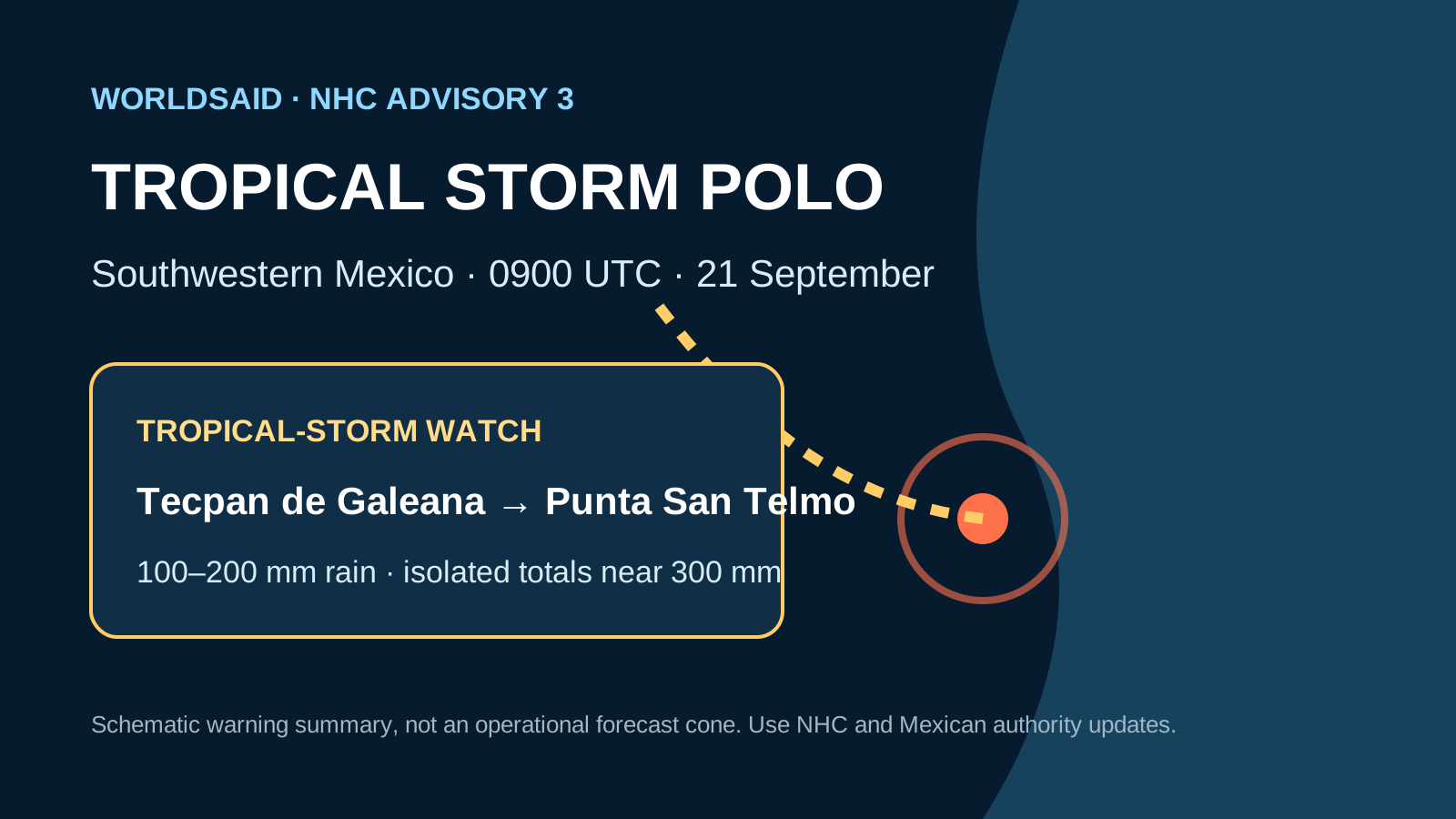
Tropical Storm Polo strengthened off southwestern Mexico from 21 September 2026. The National Hurricane Center issued a tropical-storm watch and forecast heavy rainfall. On 27 September, EFE/Telemundo reported two children found dead after a flash flood in La Cuesta, Talpa de Allende, while their parents remained missing; a separate 24-year-old tourist was missing at sea near Puerto Vallarta. These are two distinct Jalisco incidents: two confirmed deaths and three missing people in total across the cited local reports. The reports link the incidents to Polo-related rain and high surf; they do not establish direct cyclone landfall.
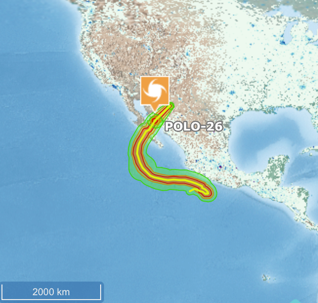
GDACS’s 28 September assessment is Orange / medium humanitarian impact and models about 230,000 people in the Category 1-or-stronger wind footprint, revised from the previously reported 239,000. Earlier 6,459, 243,000 and 84,518 exposure snapshots remain in the evidence history where reported. These are modelled hazard-footprint exposure estimates, not observed affected, displaced or casualty totals; they are kept separate from the Jalisco incident reports.
Linked charities and agencies
WorldsAid verification
A WorldsAid editor reviewed this record against 5 attributed sources, cleaned feed formatting and checked the crisis, place and reporting date. 14 human-impact figures were separated from the narrative and dated where the source allowed. Earlier observations remain in the evidence history instead of being silently overwritten.
Verified figures
- Deaths
- 2 retained at 2026-09-29
- Maximum sustained winds
- 287 km/h · Category 5 · GDACS event maximum retained at 2026-09-29
- Modelled Category 1+ exposure
- About 230,000 people in Mexico · GDACS 28 September; previous snapshot 239,000 retained at 2026-09-29
- GDACS alert
- Orange · medium humanitarian impact retained at 2026-09-29
- Forecast rainfall
- 100–200 mm; isolated totals near 300 mm through 24 September retained at 2026-09-29
- Event period
- 21-28 September 2026 retained at 2026-09-29
- Scope note
- Exposure is modelled hazard-footprint population, not an observed affected or displaced count retained at 2026-09-29
- Reported deaths
- 2 children in La Cuesta, Talpa de Allende · EFE/Telemundo, 27 September retained at 2026-09-29
- Missing people
- 3 across separate incidents: two in La Cuesta and one tourist missing at sea near Puerto Vallarta · EFE/Telemundo, 27 September retained at 2026-09-29
- Latest status · 29 September
- Reuters reports Polo made landfall in the southern half of Baja California Sur as a Category 2 hurricane south of Las Barrancas; heavy rain, flooding and mudslide risks continued. The NHC forecast a second mainland landfall. retained at 2026-09-29
- Scope note · landfall
- The Baja California Sur landfall is a separate geographic observation from the Jalisco incidents and GDACS modelled exposure; no new casualty total reported here. retained at 2026-09-29
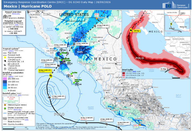
- Temporary shelters · ERCC map, 28 September
- 160 temporary shelters shown in the map’s impact overview; this is a facility count, not a displaced-person total. retained at 2026-09-29
- Rainfall exposure · ERCC map, 28 September
- Approximately 999,800 people within the map’s 100–500 mm rainfall exposure estimate; modelled exposure, not confirmed impact. retained at 2026-09-29
- Wind exposure · ERCC map, 28 September
- Approximately 36,400 people in the map’s ≥119 km/h wind buffer; a map-specific estimate, separate from GDACS’s Category 1+ footprint estimate. retained at 2026-09-29
What we knew when
- WorldsAid record entered the retained historical dataset.
- NHC advisory 3: 75 km/h winds; tropical-storm watch issued; rapid intensification forecast preserved as a dated, source-linked observation. Source
- GDACS GREEN · LOW HUMANITARIAN IMPACT · 287 KM/H CATEGORY 5 EVENT MAXIMUM · 6,459 PEOPLE MODELLED IN CATEGORY 1+ WIND FOOTPRINT preserved as a dated, source-linked observation. Source
- GDACS ORANGE · MEDIUM HUMANITARIAN IMPACT · 287 KM/H CATEGORY 5 EVENT MAXIMUM · 239,000 PEOPLE MODELLED IN CATEGORY 1+ WIND FOOTPRINT preserved as a dated, source-linked observation. Source
- GDACS RED · HIGH HUMANITARIAN IMPACT · SCORE 2.5 · 287 KM/H CATEGORY 5 EVENT MAXIMUM · 243,000 PEOPLE MODELLED IN CATEGORY 1+ WIND FOOTPRINT preserved as a dated, source-linked observation. Source
- GDACS GREEN · LOW HUMANITARIAN IMPACT · SCORE 0.5 · 287 KM/H CATEGORY 5 EVENT MAXIMUM · 84,518 PEOPLE MODELLED IN CATEGORY 1+ WIND FOOTPRINT preserved as a dated, source-linked observation. Source
- EFE/Telemundo reported two children found dead after a flash flood in La Cuesta, Talpa de Allende; their parents remained missing. A separate 24-year-old tourist was missing at sea near Puerto Vallarta. Distinct incidents; reports associate conditions with Polo-related rain/high surf, not direct landfall. preserved as a dated, source-linked observation. Source
- Reuters reported Polo made landfall early Tuesday in the southern half of the Baja California peninsula as a Category 2 hurricane, with gusts up to 200 km/h; a second mainland landfall was still expected. This does not alter the separate Jalisco incident tally. preserved as a dated, source-linked observation. Source
- European Commission ERCC Daily Map (Mexico | Hurricane POLO, 28 September) lists 160 temporary shelters and estimates approximately 999,800 people exposed to 100–500 mm rainfall and approximately 36,400 within its ≥119 km/h wind buffer. These are map-specific facility and modelled exposure figures, not observed affected, displaced or casualty totals; they are not interchangeable with GDACS wind-footprint estimates. preserved as a dated, source-linked observation.
Earlier figures are never replaced by later values; additional observations are retained as new ledger entries.
Provenance
This page renders the last verified WorldsAid cache directly in HTML. It does not treat generated summaries as primary evidence.
Cached dataset: worldsai_drup771.sql.gz
Verified
SHA-256 482a7eeb096d7091cfe30bb3cc12c89c8252d48948a7accca153cff386377627- National Hurricane Center · Tropical Storm Polo advisory 3 · 21 September 2026
- Associated Press · Polo forecast to intensify near southwestern Mexico · 21 September 2026
- GDACS · Tropical Cyclone Polo in Mexico · 21-28 September 2026
- EFE / Telemundo · Two children dead and three people missing in Jalisco incidents amid Polo impacts · 27 September 2026
- Reuters · Hurricane Polo landfall in Baja California Sur and continued mainland threat · 29 September 2026